
What is the Weather Downtime?
The Weather Downtime is defined as the time during which it is not going to be possible to work due to the metocean conditions, depending on thresholds defined for each task or each piece of equipment. It is also refered to as the Weather Standby.
The tool developed by NOVELTIS allows managing a full offshore project, mixing phases of onshore and offshore operations.

Answering most questions about your project
It can be used in 3 different ways in order to:
Starting date
to determine the starting date that will provide the shortest possible project duration, to minimize the global cost.
Duration
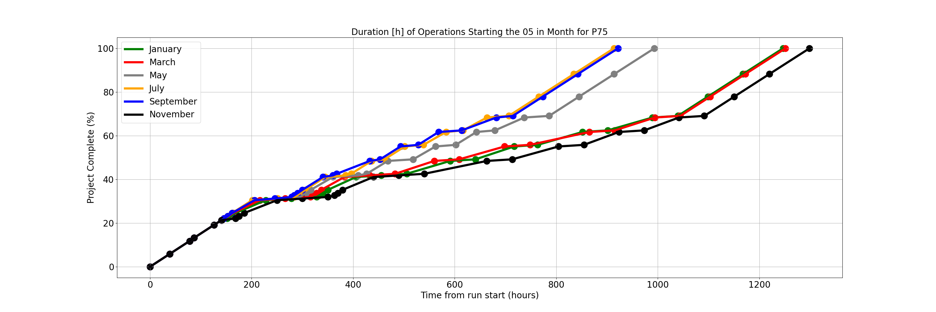
to calculate the probable duration of the whole project,according to which quantile is most appropriate : P50, P75 , P90…
Updated end date
to use the Weather Downtime tool is to feed it with forecast data instead of historical data. All tasks are updated and the completion date is easy to read.
What we need:
Every organisation has its own way of structuring
information. No need to change your logic.
Just send an Excel or a csv file with the task sequence
of your project and we will integrate it for you.
What you get:
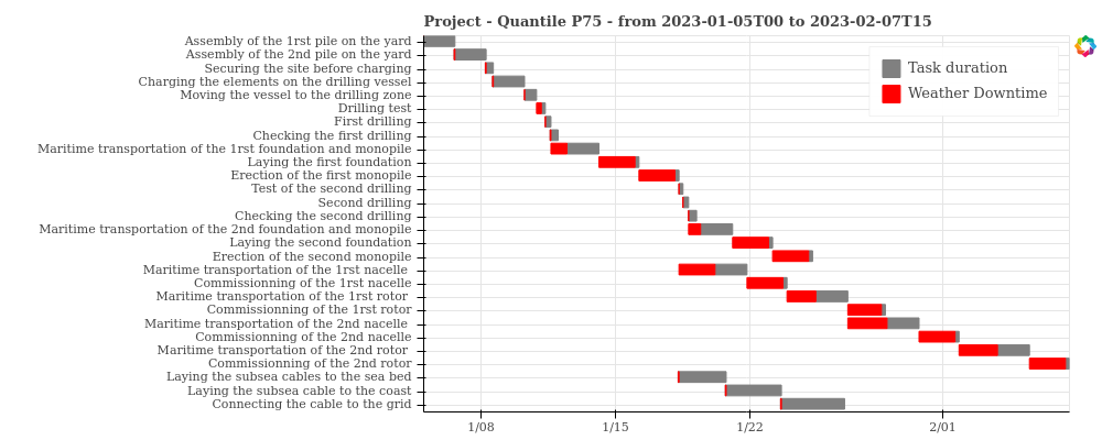
- a series of Gantt charts from P0 to P100
- the duration of your project according to your starting date
- the variance according to which quantile you look at
Technical features
- Multi parameters constraints :
- Vessel speed as a function of HS
- Thresholds as function of HSTP and wave direction
- Parallel tasks
- Combination of onshore and offshore operations
- Indication of the main risk drivers
- Up to 30 years worth of historical data
Main Applications
- Bid Management
- Bid assessment
- Project optimisation
- Logistics optimisation

About NOVELTIS
Leading company in the field of Space, NOVELTIS has been taking part in the definition and development of future European and international satellite missions for more than 20 years, in close relationship with international research laboratories and space agencies, such as CNES, ESA, EUMETSAT…
NOVELTIS harnesses and adds value to the satellite data and to environmental models, to provide innovative solutions for the characterization and monitoring of environmental phenomena, and for the prevention of risks at sea, on land and in the atmosphere.
Typical metocean studies include :
- Submersion studies
- Characterisation and forecast of the coast line evolution.
- Assessment of the wind potential of an offshore site,
- Metocan studies to determine the characteristics of a platform, of a floating wind turbine, of a port facility…
- Studies of monthly weather dowtime for offshore projects in order to assess the total duration of the operations,
- Reconstitution of the metocean data that were prevailing during a shipwreck,
- Fine-scale weather report and alarms based on personalized thresholds,
- Ideal weather window to set sails in order to benefit from the most favourable conditions in terms of safety, comfort, fuel savings or speed,
- Weather routing for wave sensitive shipping (barges, towing…)
- Forecast of the ice thickness to determine the adequate class of ice-breaker.
- Mapping of the most powerful currents for the renewable marine energies.
Send Us A Message